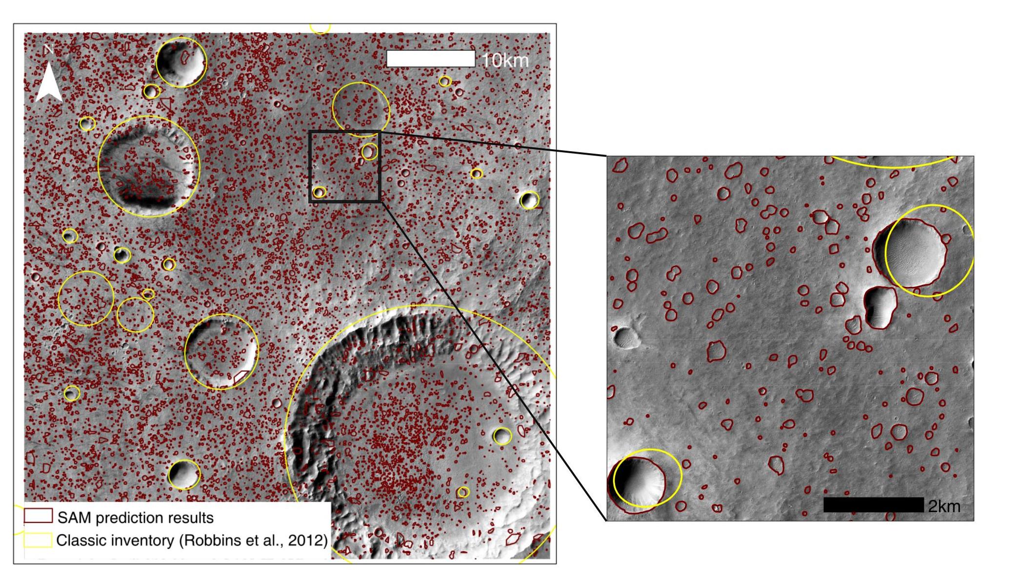
Crater
Knowledge about the geographic information of craters on Mars provide critical information in making route plan for rovers and investigating the origin of this enigmatic red planet. However, the accuracy of the present-day Martian crater inventory can still be improved as some boundaries are not delineated accurately, and many small-size craters are missing. Classic deep learning algorithms meet challenges in spatial generalization and can have adequate performance in a given region when sufficient pre-training is deployed. The state-of-the-art semantic segmentation model, Segment Anything Model (SAM), achieves unprecedented generalization from prior knowledge from considerable datasets. Yet SAM has not been effectively transferred to downstream tasks, and thus the semantic information is missing in the results. We employed a feature-based method to implement a zero-shot transfer from SAM to crater delineation. Here we apply the 5-m-resolution CTX panchromatic scenes, allowing for the delineation of small-size craters. Compared to classic deep learning models, our approach has improved the accuracy by ~10% in resolving the geographic boundaries of craters. Thrillingly, the generalization performance increases by 60%-100%, enlightening the potentials of SAM in crater inventory for the entire Mars.
Landslide
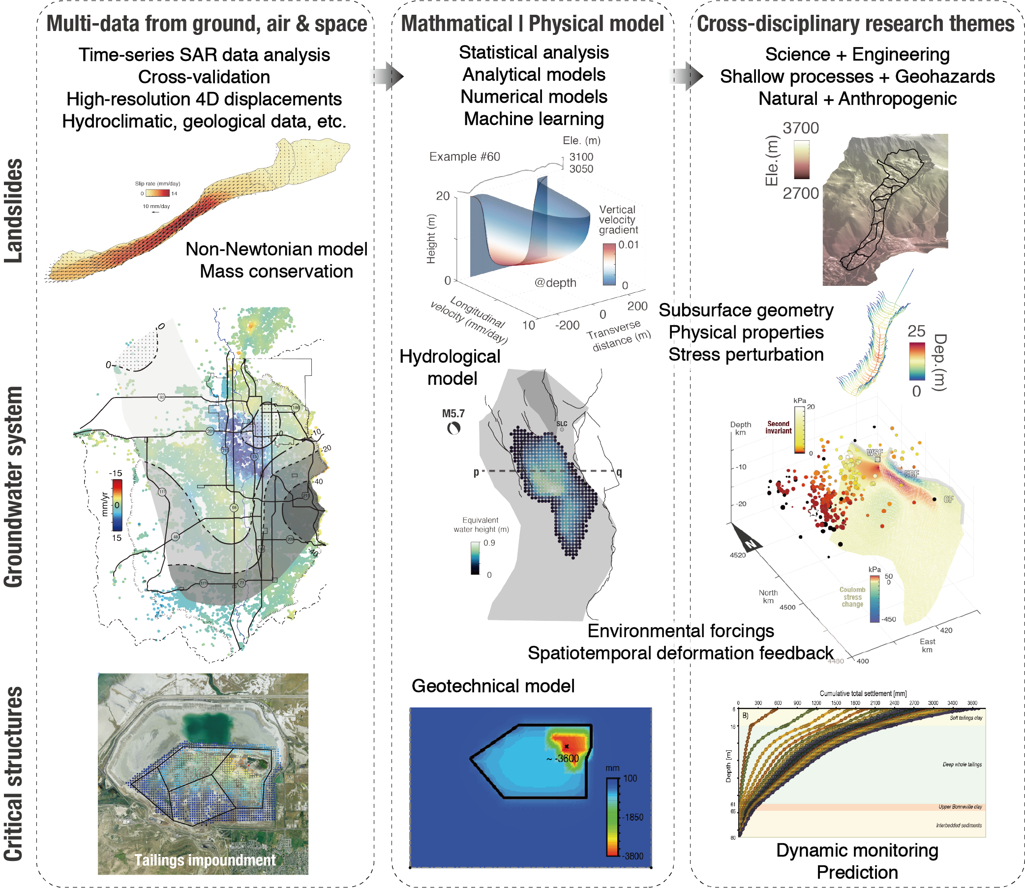
Landsliding is an intriguing interdisciplinary subject associated with geophysics, hydrology, geology, geomorphology, geodesy and geotechnical engineering. Researchers use their specialties to study fundamental questions related to the triggering mechanisms using the Coulomb stress-transfer model or the viscoplastic flow model. I intend to use SAR imaging techniques to derive spatiotemporal displacements and to develop physical models for a better understanding of landslide dynamics.
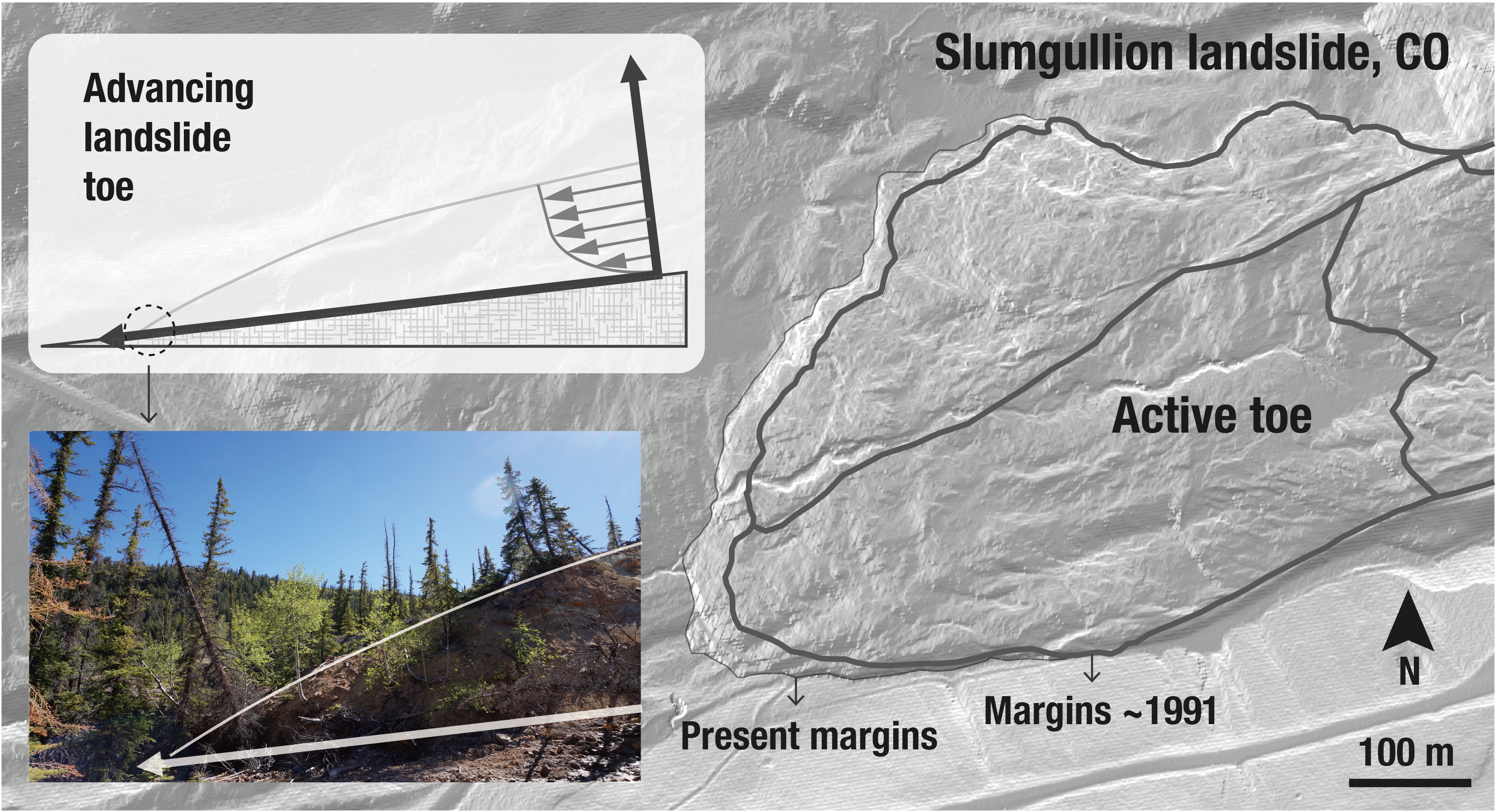
Slumgullion landslide, CO
With its large area of ~1 km2 and perennial motions at ~10-20 mm per day, the Slumgullion landslide in Colorado, USA, represents an ideal natural laboratory to better understand landslide behavior. Here, we use hybrid remote sensing data and methods to recover the four-dimensional surface motions during 2011-2018. We construct a mechanical framework to quantify the rheology, subsurface channel geometry, mass flow rate, and spatiotemporally dependent pore-water pressure feedback through a joint analysis of displacement and hydrometeorological measurements from ground, air and space.
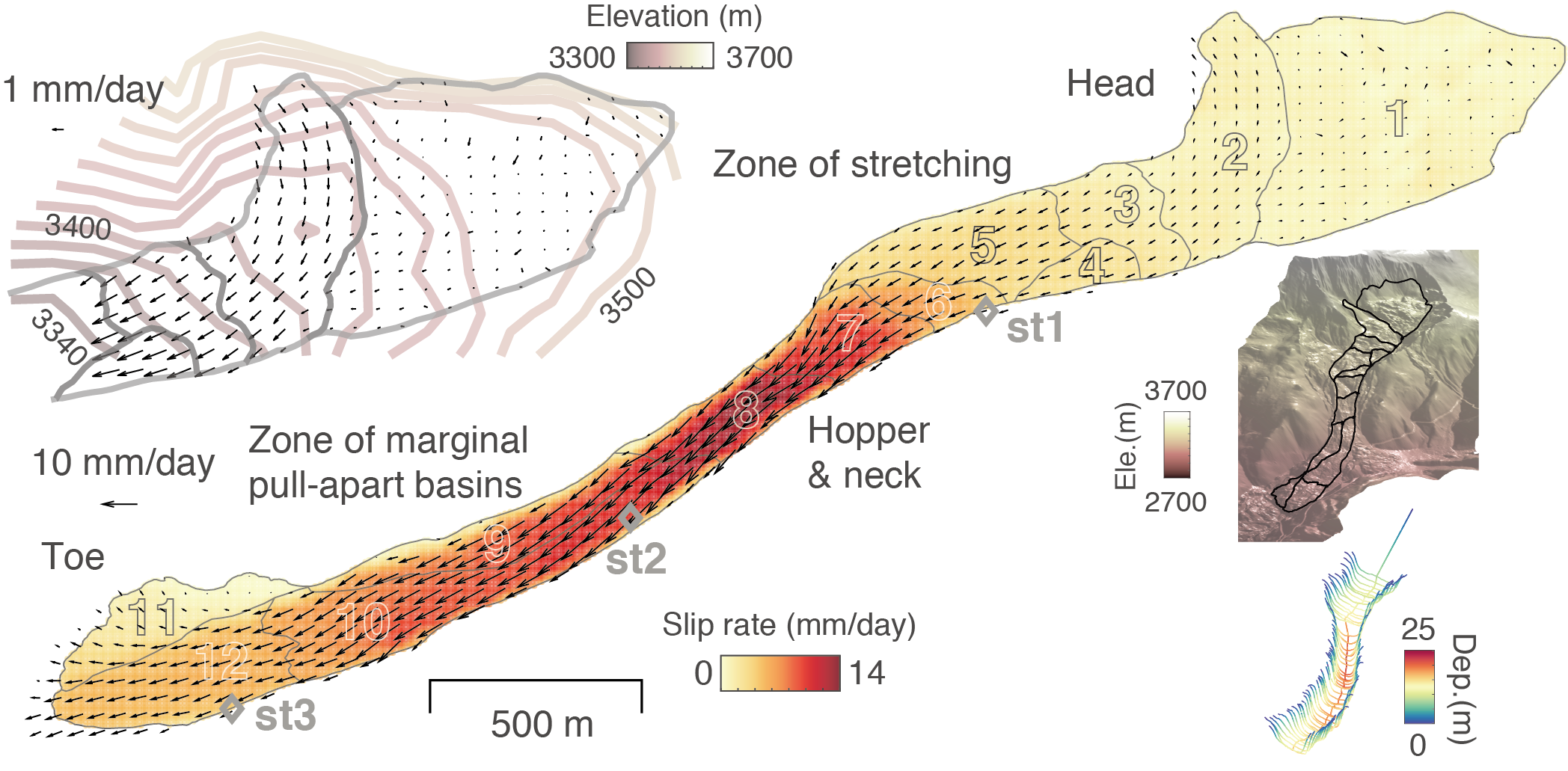
A joint analysis of UAVSAR InSAR-derived surface displacements and LiDAR DEM-derived landslide thickness at its toe allows us to invert for the intrinsic viscosity (109~1011.5 Pa·s under different degrees of plasticity) based on the Bingham plastic model.
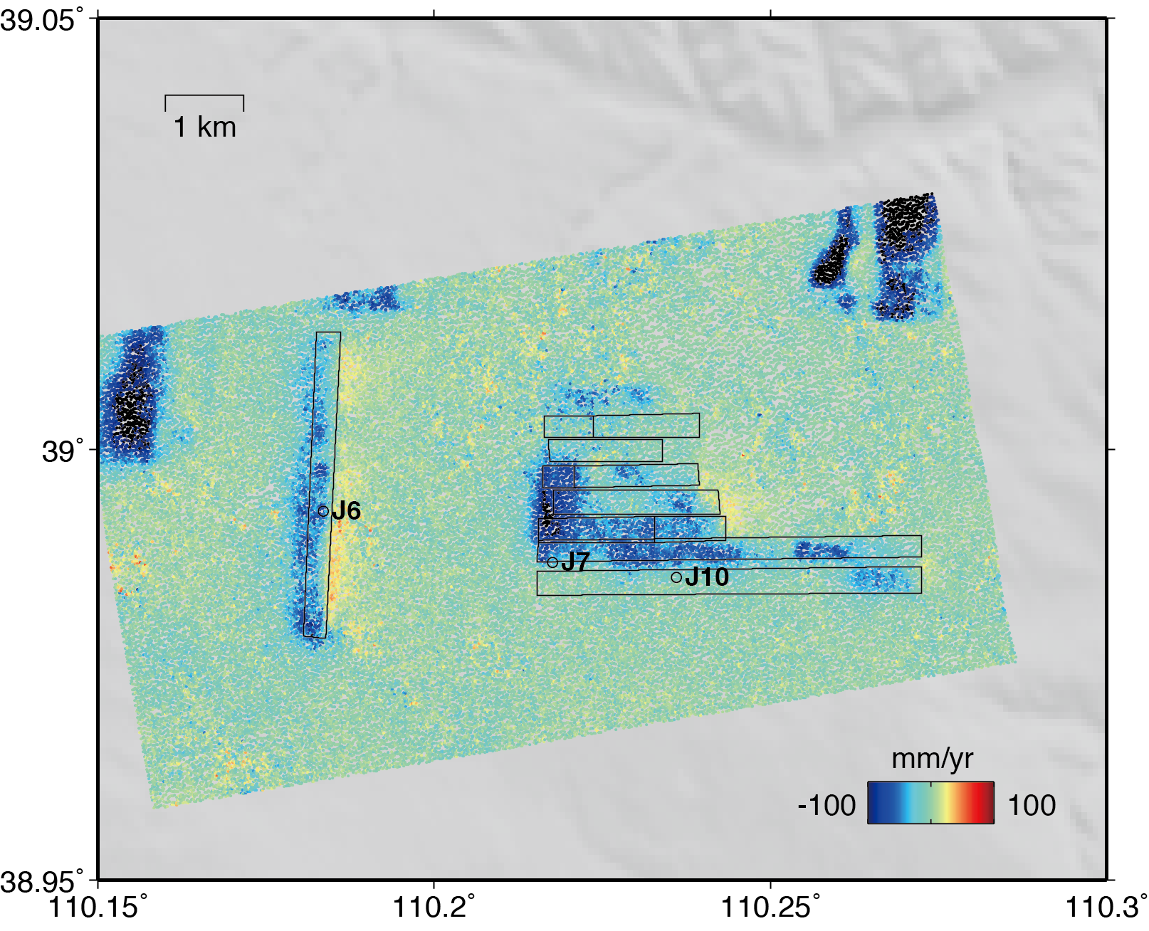
Landslide in East San Francisco Bay, CA
The East San Francisco Bay is a highly urbanized area with ~2.5 million residents (2010 census). The East Bay Hills (EBH) host the active shallow fault structure of right-lateral strike-slip Hayward fault which transverses several slow-moving landslides. EBH landslides is one of the earliest test sites on the time-series InSAR application in landslide terranes. Decadal spaceborne SAR observations from C-band ERS-1/2 and ENVISAT, L-band ALOS, and X-band TerraSAR-X and COSMO-SkyMed have been applied to characterize the regional displacements or that over specified target areas. However, the high resolution airborne UAVSAR data, with divergent trajectories, have not been explored for the EBH landslides. For scientific and societal reasons, we directly aimed at mapping the complete 3D motions and investigate the contemporary tectonic coupled landslide behaviors in terms of their respective stain rate through a joint geodetic analysis of UAVSAR, Sentinel-1, ALOS-2, GPS, creepmeter, and LiDAR data sets.
Monroe landslide, CA
Similar to the shape of the Slumgullion landslide, Monroe landslide is an elongated landslide with the ratio between the length and width >10. We inverted for a landslide thickening at the intersection between the ground subsidence and uplift in the middle part. We also simulated the pore pressure changes at depth using the rainfall records, and their correlation with time-dependent landslide rates allows us to characterize the landslide diffusivity.
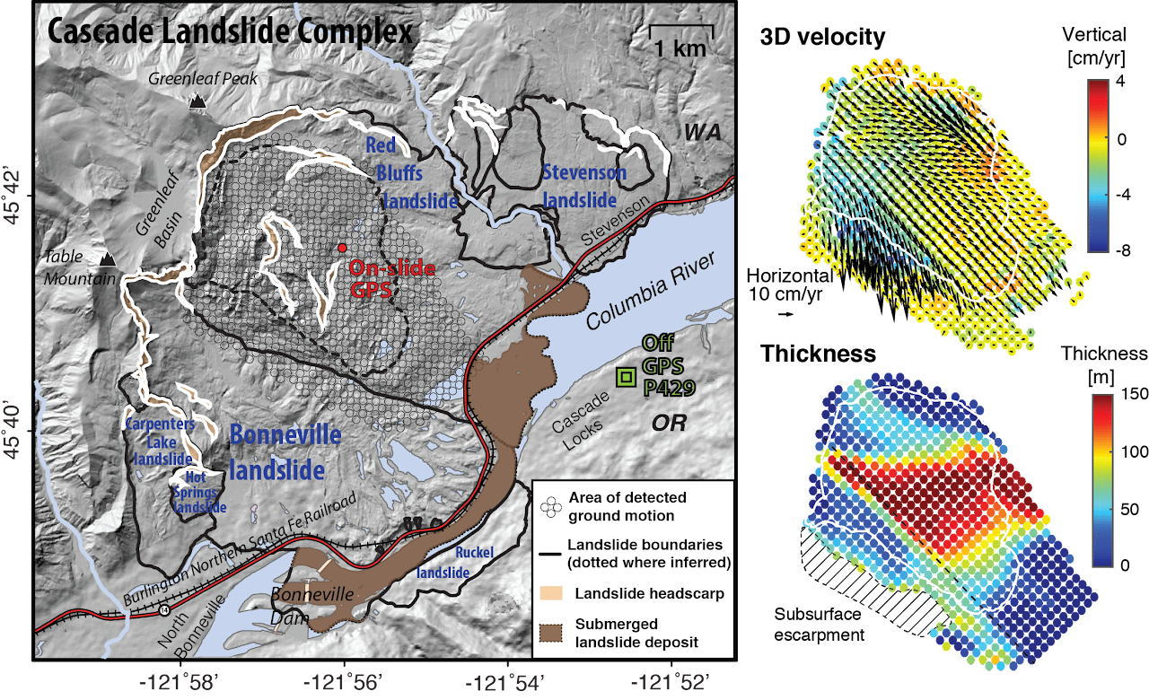
Crescent Lake landslide, WA
We found precursory slope-normal subsidence during antecedent rainfall, and the consequent increase in pore pressure at the basal surface reduces friction and instigates downslope slip in the course of less than one month. We also applied the 3D displacements to invert for the landslide basal geometry
Hydrodynamics and seismicity
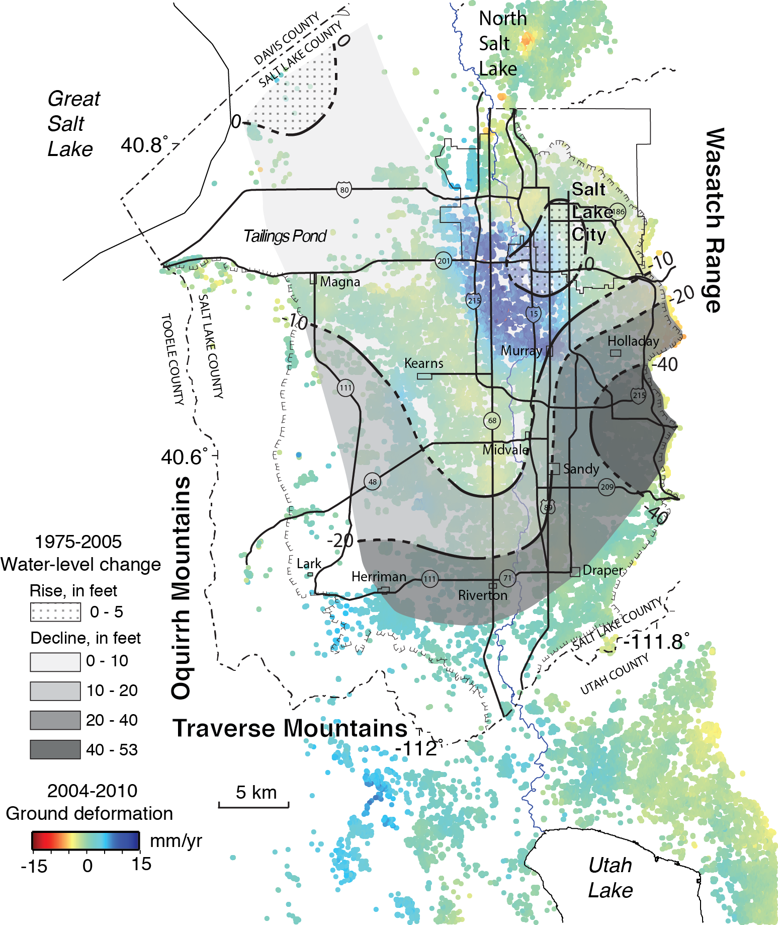
Aquifers and fault zones are two types of subsurface systems that may interact with each other through groundwater flow and stress redistribution. We demonstrate a highly effective method for not only detecting but also quantifying the changes in water storage and in stress state of critical faults within and around the aquifer system using ground deformation mapped by Sentinel-1 SAR imagery (2014-2019). We apply our method to Wasatch Fault Zone near the highly populated Salt Lake City—an overdue fault system with intense seismic risks.
Aquifer / groundwater reservoir
Aquifer skeletons deform actively in response to groundwater redistribution and hydraulic head change with various time scales of delay and sensitivity. However, determining the key hydrogeological properties generally requires the analysis of dense water gauge data and expensive drilling data. We investigated the spatiotemporal correlation among various hydrological records and ground deformation measured by InSAR observations in Salt Lake Valley, Utah. InSAR results show a clear long-term and seasonal correlation between surface uplift/subsidence and groundwater recharge/discharge, with evidence for the net uplift of 15 mm/yr for a period of six years. The long-term uplift, remarkably bounded by faults and contained within the water discharge area, reflects a net increase in pore pressure associated with a prolonged water recharge that probably occurred decades ago. The deformation and its correlation with head changes allow us to quantify hydrogeological properties. The decay coefficient and the distribution of both previously mapped faults and newly mapped faults within the fields of deformation suggest that the faults disrupt the groundwater flow and partition the hydrological units.
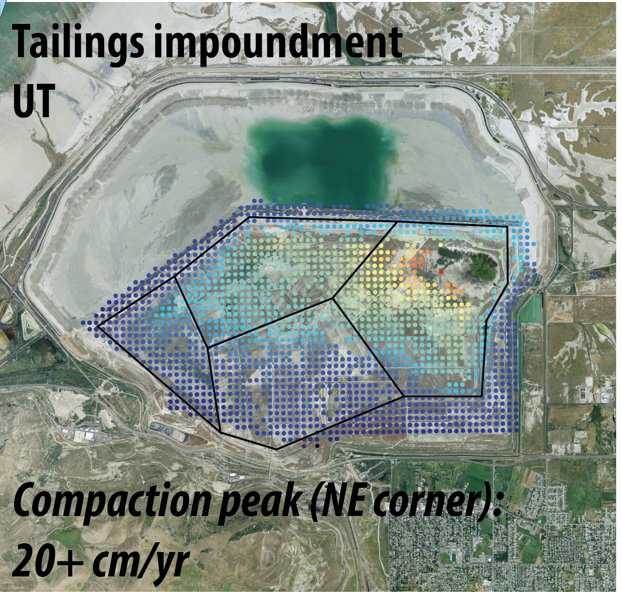
Tailing embankment
Tailings experience gradual consolidation settlement as the pore pressure dissipates and the terrain subsides. Monitoring the stability of the tailings facility is indispensable for sustainable mining development. We integrated SAR and DEM datasets to investigate the dynamics of consolidation settlement over the tailings impoundment area in the vicinity of the Great Salt Lake, Utah.
Delta and levee
The ~3,000 km2 Sacramento-San Joaquin Delta, made up of ~70 major island, is the largest estuary along the west coast of the United States. Most of the islands’ elevations are below the sea levels, in a local sea-level rise scenario of ~2 mm/yr. In addition, persistent ground subsidence has been observed since late 1800s when reclamations started, in the forms of controlled burning and water drainage for agriculture, as well as the construction of levees/embankments. Beyond that, the Delta is in the context of active Hayward-Calaveras fault zone and is facing the potential seismic-induced liquefaction and embankment failure. All those factors make the estuary especially vulnerable to inundation and land lost. We are using Sentinel-1 and UAVSAR data to characterize the surface dispalcements and land cover changes.
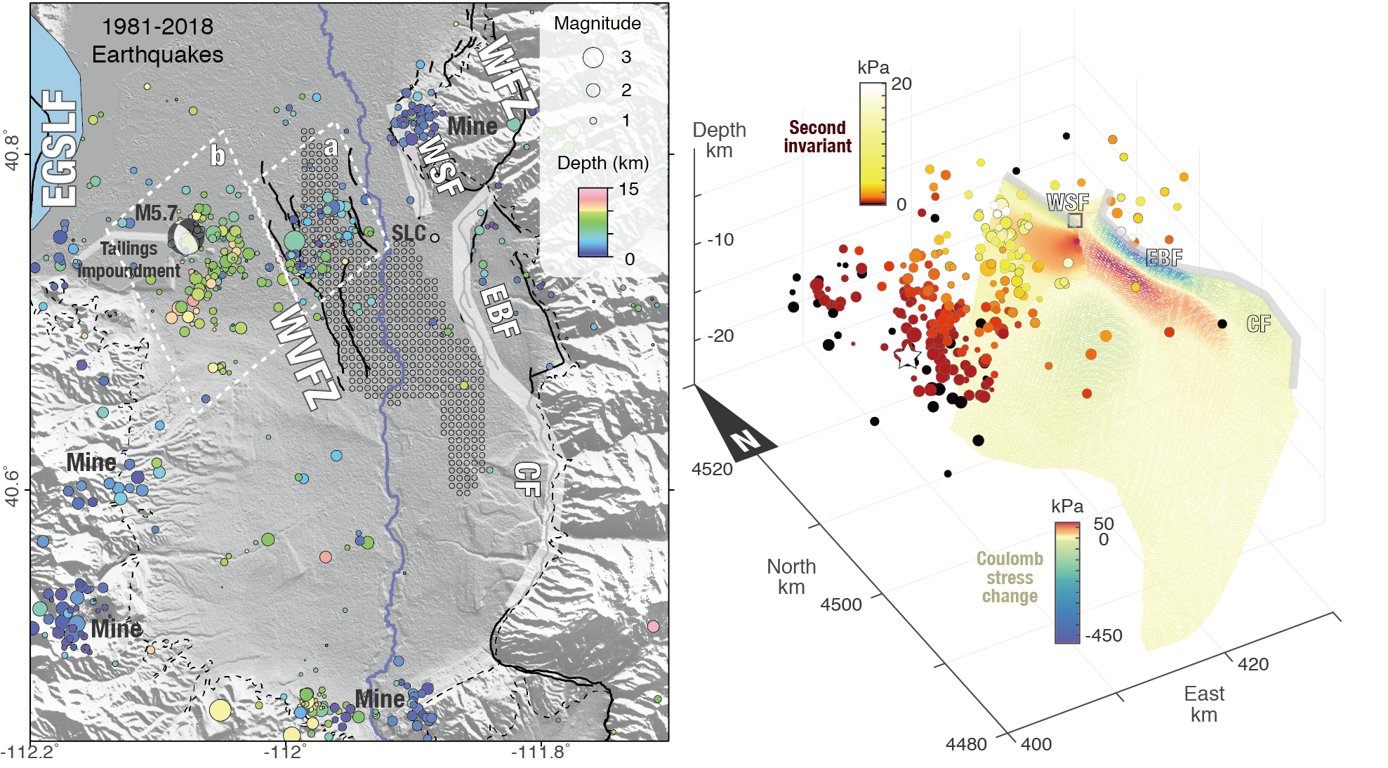
Hydro-mechanical coupling in a mining area
The hydro-mechanical coupling in the shallow crust influences both geologic processes such as earthquake and landslide and anthropogenically induced processes such as induced seismicity and mining-produced subsidence. Yet there have been few cases of direct field observation to illustrate how the hydraulic and the mechanical processes may be coupled. In this study we provide such a case by using continuous water level data and ground deformation data of an active coal mining in NW China to examine the hydro-mechanical coupling in the shallow crust. We show that the phase shift of the tidal response of water level responded to significantly to mining disturbances when the excavation workface was many hundred meters to >1 km away, while large ground deformation and water-level drop occurred only when the workface came much closer to the wells…
Earthquake
Pixel offset tracking is an important complement to measure large ground displacements in both azimuth and range dimensions where SAR interferometry is not feasible, such as in the near field of coseismic displacements. However, the conventional pixel offset tracking method is limited by redundant computation and incorrect estimations on decorrelated patches. We proposed a simple strategy that performs offset tracking on detected point-like targets (PT). We first detected image patches within bright PT using a sinc-like template from a single SAR image, and then performed offset tracking on them to estimate the shift of a PT. Compared with the standard method, the application on the 2010 M7.2 El Mayor–Cucapah earthquake shows that the proposed PT offset tracking can significantly increase the cross-correlation and thus result in both efficiency and reliability improvements[Hu et al., 2014, IEEE GRSL].